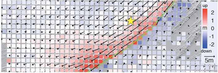
报告题目:High-resolution near-filed deformation revealed from SAR imagery
报告人:王腾 博士,南洋理工大学新加坡对地观测中心
时间: 2016年11月28日(星期一)上午10:30
地点:实验2号楼502会议室
报告摘要:
Ground deformation is important for understanding many geodynamic processes such as earthquakes, landslides, volcanic eruptions, aquifer systems, and many more. Synthetic Aperture Radar (SAR) imagery is a powerful tool that allows for mapping ground deformation in the resolution of a few meters. However, current SAR applications often suffer from decorrelation in the near filed, causing data gap near the ruptured crust. Here I will present how SAR imagery can be improved for retrieving the missing near-filed deformation via five independent cases:
1) The 2011 Van (Turkey) earthquake. In this case we show that by focusing on pre-detected sub-images containing strong reflectors, we can retrieve near-filed deformation from a pair of completely decorrelated SAR images.
2) The 2013 Balochistan (Pakistan) earthquake. In this case we show that decorrelated SAR images, even in non-interferometry modes, can still be useful in deriving the 3D coseismic displacement field. We also show interesting co-seismic and post-seismic deformation patterns near the ruptured surface revealed from SAR imagery.
3) The 2001 Bhuj (India) earthquake. In this case we show that by taking advantages of multi images, SAR offsets between ERS and ENVISAT datasets can be calculated to reveal, for the first time, the near-field coseismic displacement field.
4) The 2014-15 Holuhraun fissure eruption at Bárðarbunga volcano, Iceland. In this case, we show the detailed time-series 3D deformation of a forming graben. We also show that the near-filed 3D deformation map can tell us how the curst is exactly opened during an oblique rift event.
5) The 2016 Kumamoto (Japan) earthquake sequence. In this case, we show how to fully exploit the coherent and incoherent information in the Sentinel-1 TOPS data for retrieving coseismic displacement. We will also show the detailed 3D deformation by combining images acquired from the two latest SAR sensors: the ESA Sentinal-1A and the JAXA ALOS-2.
The five cases presented here demonstrate that the application of SAR imagery can be further extended to the near field for revealing unprecedented deformation map near the ruptured crust. Such detailed geodetic measurement will help geophysicists better understand what happened beneath the surface.

报告人简介:王 腾,工学博士,南洋理工大学新加坡对地观测中心(Earth Observatory of Singapore)高级研究人员(Senior Research Fellow )。 2010年在武汉大学廖明生教授和米兰理工大学Fabio Rocca教授(2013年度中国国际科技合作奖获得者)指导下获得两校双博士学位,并获得2009年度国家优秀留学生奖。2010-2015年在沙特阿卜杜拉国王科技大学(KAUST),2015-2016年在美国南卫理公会大学(Southern Methodist University, SMU)进行博士后研究。主要从事合成孔径雷达干涉测量(InSAR)和像素偏移(offset tracking)技术在地表形变方面的研究。近年攻克从失相干雷达影像中挖掘地表形变的难题,为研究地震、火山喷发等地质构造事件提供了前所未有的近场形变约束。已在国际SCI期刊上发表18篇论文,包括Nature子刊文章两篇,其中第一作者/通讯作者8篇。
